Cedar Canyon Petroglyphs Interpretive Site
Greater Sand Dunes SRMA, Wyoming
Added
June 30th, 2026
Adventurer unlock
Directions, weather, and nearby services help you decide if this stop works tonight.
- Directions in Google, Apple, and Waze
- Weather, cell coverage, and elevation
- Nearby services and recent check-ins

About this place
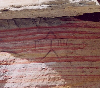
The Cedar Canyon Petroglyphs are dated back more than 200 years, with some of the petroglyphs unique to this location, including several panels that include depictions of plants and markings referred to as calendars. The surrounding landscape is known as the Red Desert, and is the traditional homeland of many Indigenous Nations who are known today as the Shoshone, Arapaho, Ute, Shoshone Bannock, Lakota, Cheyenne, and Crow tribes. Visit with respect and DO NOT climb on, touch, chalk, or otherwise alter the petroglyph panels in any way.Cedar Canyon is south of Fifteen-mile Knoll and southwest of Pine Canyon. Cedar Canyon has an elevation of 6,542 feet. The panels are a short uphill walk from the parking area. This is a fee-free site. Access is by remote routes and use of a high clearance, 4-wheel drive vehicle is recommended. Access road is not maintained and includes patches of loose sand. There is spotty cell service at the site.
Details
GPS 41.89203, -109.09280
Phone
None
Website
None
Nearby places
- Continental Divide National Sc Campground (Free Public) 1.2 mi
- Continental Divide Snowmachine Tourist Attraction 1.2 mi
- North Table Rock Camping Area Campground (Free Public) 4.4 mi
- Crookston Ranch Cultural Site Tourist Attraction 4.5 mi
- Boar's Tusk Tourist Attraction 7.3 mi
- White Mountain Petroglyphs Campground (Free Public) 8.6 mi
- Sand Dunes WSA Hiking Trail 11 mi
- Tri-Territory Site Tourist Attraction 12 mi
Check in
Share a visit note and optional photos for other travelers.
Sign in to check in, save this place, or add your own.
Recent check-ins
No check-ins yet for this place.